Water sports such as surfing, bodyboarding, windsurfing, and kiteboarding are physical activities that are mostly practiced outdoors, especially in the oceans.
Therefore, it is essential to understand our planet's "operating system" and how and why some phenomena occur on Earth.
The atmospheric and meteorological conditions are elements and variables that influence the ocean conditions and the surrounding context.
In addition to being useful for knowing how to interpret our planet's reactions, it is also quite advantageous in terms of predictions and precautions we may need to obtain the best possible prognosis and forecasts.

The Atmosphere
Generally speaking, the atmosphere is a gaseous mass surrounding the Earth and acting as a protective filter.
Without it, life would not exist on our planet.
The Earth's force of attraction holds the atmosphere around the planet, making it follow its rotation.
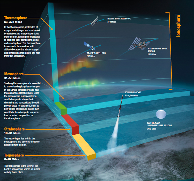
This protective filter encapsulating our planet extends to about 10,000 kilometers (6,200 miles) and is divided into several layers.
The troposphere is located close to the Earth's surface, extends up to about 12 kilometers (7.4 miles) in altitude, and is where meteorological phenomena occur.
The stratosphere extends up to around 50 kilometers (31 miles) in altitude and features temperatures below 0 °C (32 °F).
The ozone layer, responsible for filtering the ultraviolet (UV) rays emitted by the Sun, can be found in the stratosphere's lower part, at around 15-30 kilometers (9-18 miles).
The mesosphere expands up to about 80 kilometers (50 miles) in altitude and prevents asteroids and meteors from reaching the Earth by burning them.
The thermosphere extends up to about 700 kilometers (434 miles) of altitude and is a place where temperatures reach 2,000 °C (3,632 °F).
The exosphere extends to about 10,000 kilometers (6,200 miles) altitude, where there are hardly any oxygen molecules that dissipate solar heat.
The last three spheres - mesosphere, thermosphere, and exosphere - are also considered part of the ionosphere.
The ionosphere is a region that contains high electrical activity and many positive ions and free electrons.
The following illustration shows the location of the several atmosphere layers and how they remain close to the Earth's surface thanks to our planet's gravitational force.
The Science of Meteorology
Meteorology is the science that studies the meteorological phenomena in the troposphere, i.e., the atmospheric layer closest to the Earth's surface.
A good and accurate analysis of weather conditions is key to ensuring a safe and gratifying surf session.
Today, everyone can easily find weather data reports and forecasts in meteorological bulletins provided by national weather services, television, radio, press, or specialized online websites.
Meteorological events are a series of climate science occurrences that influence and impact the weather, the conditions observed at sea, temperature perception, and several other secondary situations.
All the constant changes in weather phenomena are analyzed in detail by meteorologists and forecast offices, who provide information that makes our lives safer, in and out of the water.
A degree in meteorology involves the study of the atmosphere in detail and trains future weather forecast professionals.
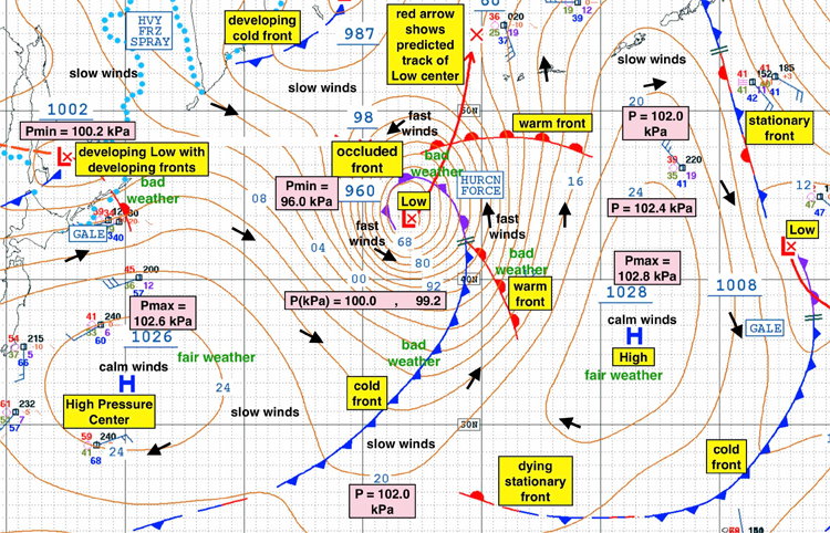
Most of the forecasts are graphically represented in weather charts, specific maps, or satellite images.
But to interpret and translate these technical documents and data into simplified information, we have to learn some basic meteorological concepts.
Interpreting a Weather Forecast
In the following paragraphs, we will break down the fundamentals of weather and modern meteorology and the multiple complex atmospheric phenomena and events that are part of our daily lives.
Deciphering the weather by looking at its classic graphical representation requires some prior knowledge.
The only way to decode the symbols or graphic signals used in meteorological charts - also known as synoptic charts or surface pressure charts - is by mastering their key functions.
Weather charts are a precious tool for predicting the best ocean conditions for water sports participants.
Before driving to a beach, it is always wise to check the weather reports and the surf forecast for the upcoming hours or days.
For instance, clouds also provide relevant information on current and future weather conditions.
Clouds are classified into three major groups according to their appearance and dimension: high clouds (Cirrus, Cirrocumulus, and Cirrostratus), medium clouds (Altocumulus and Upperstratum), and low clouds (Estratum and Stratocumulus).
Vertically developed clouds are also often included in the low cloud category.
The Anticyclone
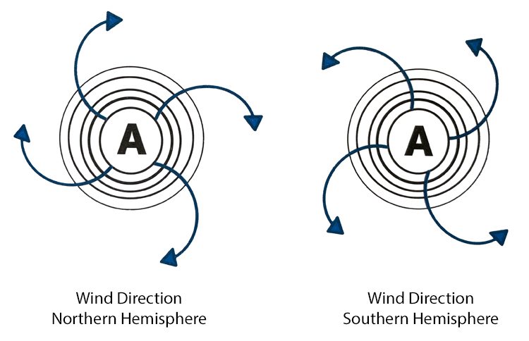
Anticyclones are considered high atmospheric pressure centers.
The anticyclone center has maximum pressure, while the peripheral zone has the lowest pressure values.
High atmospheric pressure systems are measured in pascals (Pa) or, more accurately, in hectopascals (hPa) and are often associated with good weather.
The wind produced by anticyclones descends and diverges.
In addition, the wind shifts from the center to the periphery, clockwise (from left to right) in the Northern Hemisphere and counterclockwise (from right to left) in the Southern Hemisphere.
The Depression
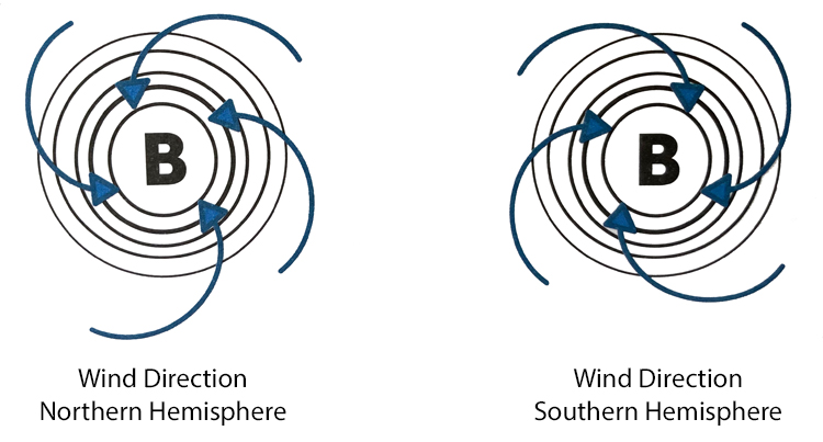
Depressions are considered low atmospheric pressure centers.
The depression center has low-pressure values, and the peripheral area has the highest pressure values.
Low atmospheric pressure systems are measured in pascals (Pa) or, more accurately, in hectopascals (hPa) and are often associated with bad weather.
The wind produced by depressions ascends and converges.
In addition, the wind shifts from the periphery to the center, counterclockwise (from right to left) in the Northern Hemisphere and clockwise (from left to right) in the Southern Hemisphere.
The Coriolis Effect
Anticyclones (high-pressure centers) and depressions (low-pressure centers) flow and circulate in our planet's atmosphere, more specifically in the troposphere, due to the so-called Coriolis effect.
The Coriolis effect is a deflective force that makes air currents and winds bend to the right In the Northern Hemisphere and makes currents and winds bend to the left in the Southern Hemisphere.
When observing a weather chart, you'll notice lines that graphically represent these phenomena and are rarely uniform or perfectly rounded.
Wind and pressure systems are never entirely predictable because the Earth has multiple unequal continental landmasses and obstacles.
These lines are called isobar or isobaric lines, and they display points of equal atmospheric pressure.
As a general rule of thumb, the farther away they are from each other, the lower the wind intensity, and vice versa - the closer they appear on the map, the greater the wind intensity.
The Weather Fronts
Weather fronts are transition zones between air masses of several characteristics, such as air density, humidity, and wind.
They are represented on weather charts or satellite images using color graphic signals.
There are four types of weather fronts: cold fronts, warm fronts, stationary fronts, and occluded fronts.
The Cold Front

On cold fronts, the cold air, being heavier and denser, forces the warm air to rise, pushing it upward.
In other words, the displacement of a cold air mass along the Earth's surface raises warm air, which is less dense and lighter.
As a result, the cold front moves toward the warm front.
The cold front is represented on a weather map with a solid blue line with filled-in triangles.
The Warm Front

In warm fronts, warm air pushes into a cooler air mass.
In other words, because warm air is lighter and less dense, it rises above the cold air that moves along the Earth's surface.
The warm front is represented on a weather map with a solid red line with red, filled-in semicircles (warm front).
The Stationary Front

Stationary fronts form when a warm front or cold front stops moving.
The phenomenon occurs when two air masses push against each other, but neither is powerful enough to move the other.
The stationary front is represented on a weather map with alternating red semicircles and blue triangles.
The Occluded Front

In occluded fronts, the warm, moist air pushed upward in relation to the Earth's surface is completely surrounded by cooler air.
The occluded front is represented on a weather map with a purple line with alternating triangles and semicircles pointing in the direction in which the front is moving.
Air Masses
Air masses are large volumes of air that are relatively uniform in moisture and temperature and can extend thousands of miles across the surface of the Earth.
They can reach from the ground level up to the stratosphere, i.e., 10 miles (16 kilometers) into the atmosphere.
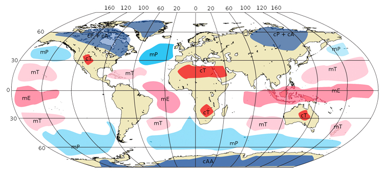
There are six types of air masses: Continental Polar (cP), Continental Tropical (cT), Maritime Tropical (mT), Maritime Polar (mP), Maritime Equatorial (mE), and Continental Arctic (cA).
Each one of these air masses has its specific characteristics and surrounding regions.
The Continental Polar Air Mass
The Continental Polar air mass appears mainly during the fall and winter seasons, carrying dry and cold air.
It arrives between October and March, originating from the coldest northern areas of the Asian continent and North America.
The blow from the East over the Iberian Peninsula and, in the United States, moves southward east of the Rocky Mountains into the Great Plains, then eastward.
In Europe, they bring offshore winds and sunny weather but also low air temperatures.
In America, they also result in cold air temperatures.
The Maritime Polar Air Mass
The Maritime Polar air mass can be found in the North Atlantic, North Pacific, and above the Antarctic.
It often transports cold and moist air collected from the oceans.
The Continental Tropical Air Mass
The Continental Tropical is often found in the tropical/equatorial regions of Africa, Asia, Australia, and Central America.
It generally transports hot, dry, and unstable air, bringing with it a lot of heat, high temperatures, and potentially severe droughts.
The Maritime Tropical Air Mass
The Maritime Tropical air mass can be found in the Central and South Pacific, Central and South Atlantic, and Indian Ocean regions.
It transports warm and humid air generated in the ocean and is often associated with rain, cloudy skies, fog, low clouds, and even thunderstorms.
Words by Nuno Beleza de Andrade | Surfer and Author of "Saber das Ondas"
