If you can read and interpret isobars on a weather map, you can get an overall idea of the meteorological conditions anywhere on Earth.
Pressure systems are differences in air pressure - peaks and lulls - within two different areas of Earth's atmosphere.
If our planet were perfectly flat and waterless or 100 covered by water, the barometric pressure would be even all around the world.
But because there are mountains and unevenly distributed land masses, air moves "randomly," up and down, slow and fast, through all these obstacles and heated/cooled surfaces (water and land).
Therefore, high and low-pressure systems are crucial in determining air movement, wind, and weather across the Earth.
Understanding and deciphering them can be helpful for various reasons, as they play a significant role in shaping weather conditions and affecting daily activities.
And that's why weather maps, also known as synoptic weather charts, exist. Some of their key applications include:
- Weather forecasting: Knowledge of high and low-pressure systems allows meteorologists to predict weather patterns more accurately. This information helps the public prepare for potential changes in the atmosphere, such as tropical storms, clear skies, or temperature fluctuations;
- Agriculture: Farmers rely on accurate weather forecasts to make decisions about planting, irrigation, and harvesting. Understanding pressure systems helps them anticipate rainfall, droughts, and temperature changes, allowing them to optimize crop yield and reduce crop damage;
- Aviation and marine navigation: High and low-pressure systems influence wind speed and direction, which are crucial factors for aviation and maritime navigation. Pilots and sailors use this information to plan their routes, avoid turbulent weather, and ensure a safe and efficient journey;
- Outdoor activities and sports: Knowledge of pressure systems helps plan outdoor activities, such as hiking, camping, and sports events. For example, surfers often rely on the interaction of high and low-pressure systems to predict wind and wave conditions. At the same time, organizers of outdoor events can make better decisions about scheduling and contingency plans based on expected weather conditions;
- Disaster preparedness and management: Understanding high and low-pressure systems can help predict severe meteorological events, such as hurricanes, cyclones, and heavy rainfall, providing crucial information for disaster preparedness and emergency response planning;
- Energy management: Weather conditions, such as wind speed and temperature, significantly impact energy demand and supply. Accurate high- and low-pressure system predictions can help energy providers and consumers make informed decisions about electricity generation, consumption, and conservation;
- Climate research: Studying high and low-pressure systems contributes to understanding Earth's climate system and long-term changes in weather patterns. This knowledge is essential for addressing climate change and developing strategies for mitigation and adaptation;

Understanding High and Low-Pressure Systems
High-pressure systems, also known as anticyclones, are regions where the atmospheric pressure at the Earth's surface is higher than the surrounding areas.
These systems typically bring clear skies and stable weather conditions.
Air in high-pressure systems descends, which inhibits cloud formation, rain, and snow.
In the Northern Hemisphere, air circulates clockwise around high-pressure systems, while in the Southern Hemisphere, it circulates counterclockwise.
Low-pressure systems, or cyclones, are characterized by lower atmospheric pressure at the Earth's surface than their surroundings.
They often bring cloudy, rainy, or stormy conditions as warm, moist air rises and cools, leading to the formation of clouds and precipitation.
Air circulation around low-pressure systems is counterclockwise in the Northern Hemisphere and clockwise in the Southern Hemisphere.

Generation and Morphing
Pressure systems are generated primarily by the uneven heating of the Earth's surface.
The Sun's rays heat the equator more than the poles, creating temperature differences that cause air to move.
This movement of air, or wind, is further influenced by the Coriolis effect, a result of Earth's rotation that causes air to be deflected to the right in the Northern Hemisphere and the left in the Southern Hemisphere.
High-pressure systems typically form when cold air from the poles moves toward the equator, while low-pressure systems develop when warm air from the equator moves poleward.
Topography, such as mountains and ocean basins, can also influence these pressure systems.
Pressure systems can change over time due to various factors, including the movement of air masses and the influence of other weather systems.
High-pressure systems can weaken as air descends and warms, while low-pressure systems can intensify as warm, moist air rises and cools, increasing the potential for stormy weather.

Common Patterns
An average person can identify high and low-pressure systems by observing the weather conditions and wind direction.
Clear skies, fair weather, and clockwise wind circulation in the Northern Hemisphere (or counterclockwise in the Southern Hemisphere) indicate a high-pressure system.
In contrast, cloudy skies, precipitation, and counterclockwise wind circulation in the Northern Hemisphere (or clockwise in the Southern Hemisphere) suggest the presence of a low-pressure system.
Some of the most common high and low-pressure systems include:
- The Intertropical Convergence Zone (ITCZ): A region near the equator where the trade winds from the Northern and Southern Hemispheres converge, creating a low-pressure system characterized by heavy rainfall and thunderstorms;
- The Subtropical High-Pressure Belts: Found at approximately 30° latitude in both hemispheres, these are zones of high pressure associated with sinking air and stable, dry conditions;
- The Polar Front: A boundary between cold polar air and warmer air from the mid-latitudes, where low-pressure systems often form, leading to the development of mid-latitude cyclones;

Isobars: Reading the Weather Map
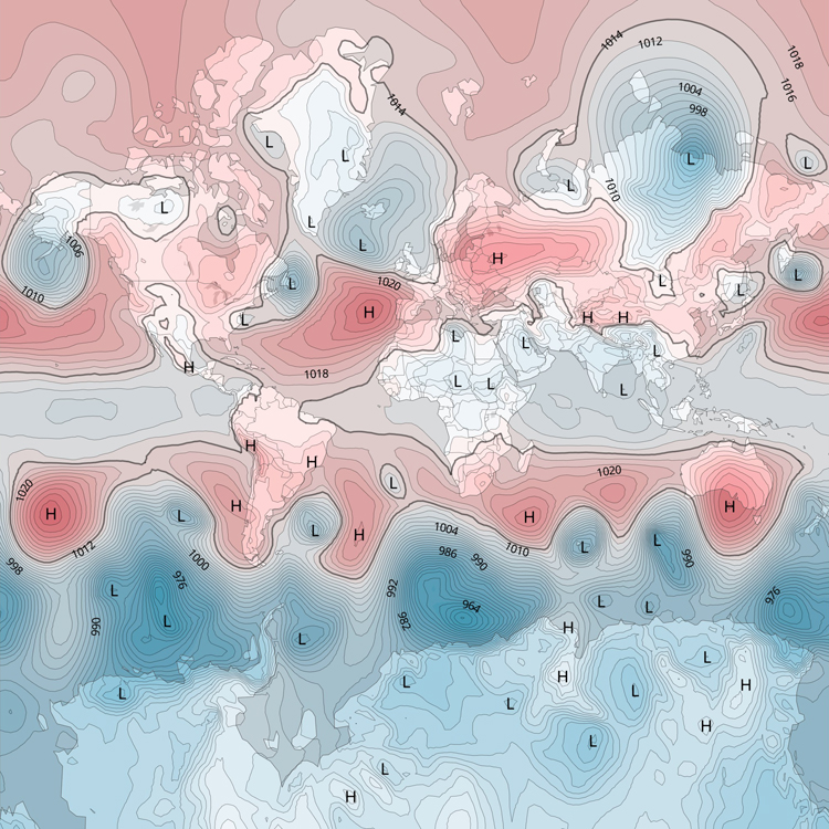
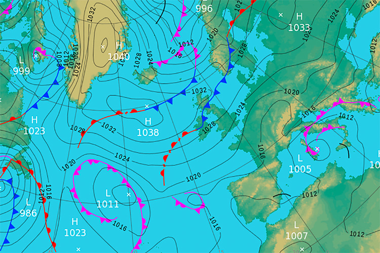
Isobars are weather map lines that connect points of equal atmospheric pressure.
They help visualize pressure distribution across a geographical area and are essential for understanding and predicting weather patterns.
Isobars are typically drawn at regular pressure intervals, such as every four millibars (mbar).
The closer the isobars are to each other, the stronger the pressure gradient, meaning stronger winds in that region.
Are you curious about how to read isobars on a weather map? Follow these steps:
- Locate the isobars: On a weather map, isobars are usually depicted as curved lines with labeled pressure values, such as 1,000 mbar, 1,004 mbar, 1,008 mbar, etc. Some weather maps may use colors or shading to distinguish between different pressure levels;
- Identify high and low-pressure systems: High-pressure systems are represented by isobars with higher pressure values at their center. In comparison, low-pressure systems have lower pressure values at their core. An "H" or an "L" symbol may be used to mark the center of high and low-pressure systems, respectively;
- Observe the spacing of isobars: The distance between isobars indicates the strength of the pressure gradient. When isobars are close together, the pressure changes rapidly over a short distance, resulting in strong winds. Conversely, when isobars are farther apart, the pressure gradient is weaker, leading to lighter winds;
- Determine wind direction: In the Northern Hemisphere, wind flows counterclockwise around low-pressure systems and clockwise around high-pressure systems. In the Southern Hemisphere, the wind direction is reversed - clockwise around low-pressure systems and counterclockwise around high-pressure systems. The wind flows roughly parallel to the isobars but is slightly angled towards low-pressure centers due to friction with the Earth's surface;
Analyzing isobars on a weather map gives one a general sense of the weather conditions in a given region, including wind direction and intensity and the location of high and low-pressure systems, which influence cloud cover and precipitation.
It only takes practice and simultaneous observation of the atmospheric conditions to get used to the barometric pressure readings.
